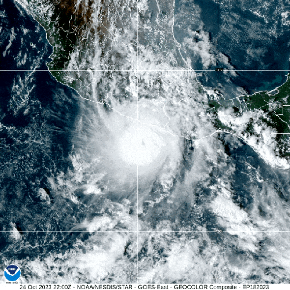
Evening had already fallen in Acapulco, Mexico, on October 24 when the weather forecast became very grim indeed. What had begun the day as Tropical Storm Otis was unexpectedly now a raging Category 5 hurricane bearing down fast on the city of nearly 800,000 people.
“A nightmare scenario is unfolding for southern Mexico this evening with rapidly intensifying Otis approaching the coastline,” wrote National Hurricane Center (NHC) officials late on Tuesday night. They predicted that the storm would bring “life-threatening” winds and “a potentially catastrophic storm surge,” as well as heavy rains, potentially triggering mudslides, through the coming days.
Hurricane Otis slammed into the city on October 25 at 12:25 A.M. local time with windspeeds of around 165 miles per hour, according to the NHC. It was the first known Category 5 storm to ever hit the region. “There are no hurricanes on record even close to this intensity for this part of Mexico,” the dire NHC forecast noted.
Now scientists are left to try to understand how the storm was able to sneak up on them, says Kristen Corbosiero, an atmospheric scientist at the University at Albany.
Forecasts made on Tuesday morning noted that local sea-surface temperatures were high, about 86 degrees Fahrenheit (30 degrees Celsius), and confirmed that the storm would become a hurricane on its way into Acapulco. But by that afternoon, NHC forecasters were clearly concerned by how Otis was progressing and highlighted the storm’s unexpected “very rapid intensification” over the course of the day.
Rapid intensification means that a tropical storm’s maximum sustained wind speeds rise by at least 35 miles per hour within a 24-hour period. Otis’s wind speeds rocketed by nearly 110 miles per hour in such a period, the second most dramatic intensification on record, according to the NHC. Rapid intensification is a terrifying and dangerous phenomenon, particularly when it occurs close to land, and it’s becoming more common with climate change.
So meteorologists are working to better understand how this process is triggered. But what exactly drove Otis’s supercharged intensification is currently puzzling, Corbosiero says. “The environmental factors that we know are important in terms of rapid intensification were favorable but nothing to hint to this extreme rate of intensification,” she says.
Those factors include warm ocean temperatures, which help feed tropical storms, and low wind shear, which allows a storm to retain its structure rather than be torn to shreds. For Otis, neither factor seems to have been particularly extreme. “The waters were anomalously warm,” Corbosiero says, “but nothing spectacularly above normal.”
Because forecasters were caught unawares, so were local residents, who only expected perhaps a Category 2 storm. “People there knew a hurricane was coming but not to this intensity,” Corbosiero says. “In terms of warnings and messaging and emergency management, it’s a really bad situation when something rapidly intensifies this quickly and is completely unexpected.”
Since making landfall, Otis has rapidly weakened but is still dropping large amounts of rain in the region. The initial force of the storm took out power and phone lines and caused landslides, including one across a major highway, leaving it difficult to evaluate the severity of the situation on the ground.
While the city recovers, meteorologists are beginning to analyze the storm and hunt for clues they may have missed. “I think everybody was generally caught off guard,” Corbosiero says. “So it’s a great case for us to look into further.”
 Rights & Permissions
